Israeli Military Apologises for Map Showing J&K as Part of Pakistan Amid Iran Conflict
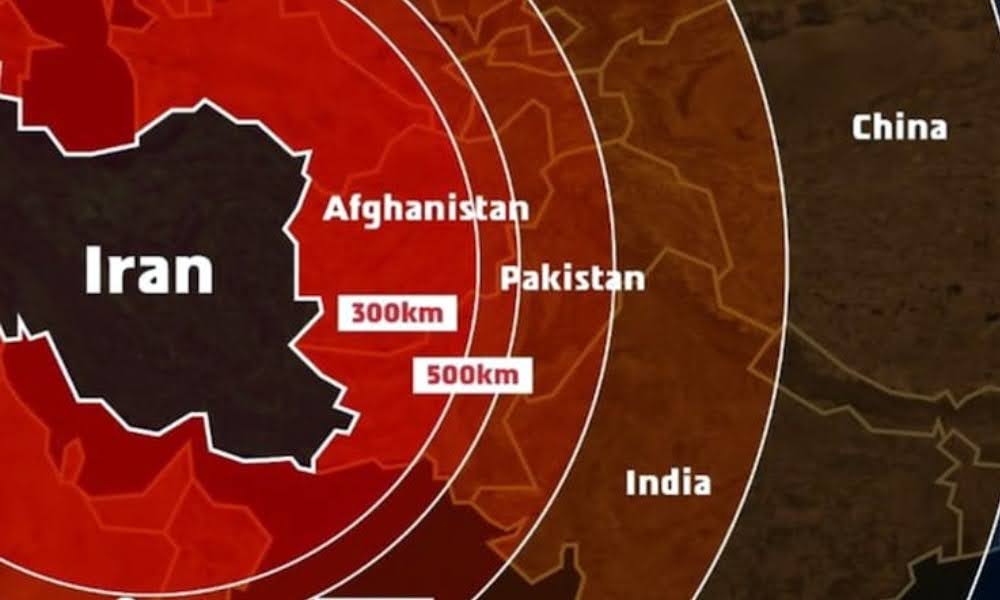
The Israeli Defence Forces (IDF) on Saturday issued an apology after sharing a map illustrating Iran’s missile range, which inaccurately showed Jammu and Kashmir as part of Pakistan and Northeast India as part of Nepal.
The military clarified that the map was not intended to reflect precise national borders.
Outrage in India Over Map Error
The apology followed a wave of backlash in India after the map was posted on Friday by the IDF amid growing tensions between Israel and Iran.
The post, meant to highlight the threat posed by Iran, was captioned with statements like “Iran is a global threat” and “Israel is not the end goal, it’s only the beginning”.
The map included India in the range of Iran’s missiles and misrepresented the country’s borders.
Responding to a flagged post on X highlighting the inaccuracies, the IDF stated, “This post is an illustration of the region. This map fails to precisely depict borders. We apologise for any offence caused by this image.”
Users Highlight Inaccuracy
Several users took to X to express their displeasure. One comment in the community notes said, “This representation has incorrectly depicted the entire map of India. The Union Territory of Jammu & Kashmir and Ladakh along with the States of Sikkim and Arunachal Pradesh are unquestionably integral parts of the sovereign territory of India and must be depicted as so.”
Many echoed the same concern, calling for correction and accountability.
Apart from India, the map also showed the missile reach covering 15 other countries, including Russia, Ukraine, China, and Sudan.
Conflict Between Israel and Iran Intensifies
The controversy emerged as Israel launched large-scale airstrikes on Tehran on Friday, claiming the operation targeted Iran’s nuclear enrichment programme.
The attack reportedly resulted in the deaths of several senior Iranian military commanders and over 70 others, along with the destruction of key facilities and several injuries.
In response, Iran launched a counterattack using drones and missiles on multiple Israeli cities, including Tel Aviv and Jerusalem. The conflict escalated further with additional rounds of attacks from both nations on Saturday.
Backlash Over IDF’s Misrepresentation
The IDF’s map quickly drew widespread criticism, especially from Indian users, for inaccurately portraying India’s territory. Indian users were quick to respond on social media, tagging Israeli Prime Minister Benjamin Netanyahu and demanding corrections.
The IDF replied within 90 minutes to a post from a handle named “Indian Right Wing Community,” reiterating the map’s illustrative nature and expressing regret.
However, the apology did little to calm public sentiment. Many users saw the mistake as a serious lapse, especially given Israel’s status as a close strategic ally of India.
One user remarked, “Now you understand why India remains neutral. In diplomacy, no one’s really your friend.”
No Official Response From Indian Government Yet
As of now, the Indian government has not released an official statement regarding the incident. However, the sensitivity of the issue remains apparent.
India has consistently maintained that Jammu & Kashmir and Ladakh, parts of which are under illegal occupation by Pakistan and China, are integral to its sovereign territory.
Prime Minister Narendra Modi reaffirmed this stance recently in the wake of the Pahalgam terror attack.
Strong Bilateral Ties With Israel
India and Israel share a longstanding relationship in defense and diplomacy. Prime Minister Modi became the first Indian PM to visit Israel in 2017.
India is also among the largest buyers of Israeli defense equipment. In terms of trade, India ranks just behind the U.S., U.K., Hong Kong, and China as one of Israel’s top trading partners.
Given the depth of the relationship, the IDF’s erroneous depiction of India’s borders took many by surprise and led to disappointment among Indians who value the strategic alliance.
Visuals That Sparked Controversy
The controversial map posted by the IDF showed red concentric circles radiating from Iran, representing missile reach. These circles covered neighboring regions, including parts of Europe, North Africa, China, and India.
The image was part of Israel’s effort to demonstrate Iran’s growing missile threat but inadvertently misrepresented international borders.
A Diplomatic Misstep Amid Escalating Conflict
The IDF’s post, intended to underline Iran’s regional threat, inadvertently stirred diplomatic sensitivities in India.
While the apology acknowledged the mistake, the incident highlighted the importance of accuracy in official communications—especially when shared amid ongoing international tensions.